Get Outdoors
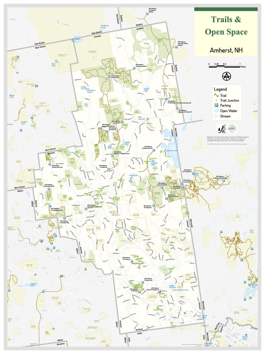
Amherst has 50 miles of trails for hiking, running, mountain biking, and snow shoeing. Below are descriptions of our trail networks. To find canoe ports, scroll to the bottom of the page. Easily accessible sites for simply enjoying a picnic or a moment of peace in nature include the Great Meadow and Lindabury Orchard.
Join Amherst Recreation for weekly walks in the woods, Wednesdays 12:30pm-1:30pm.
Visit the Amherst Recreation website for more details.

Maps & Navigation
Most trail apps work in Amherst (Gaia GPS, Trail Forks, etc.).
Try the new Avenza app. Download Amherst maps and navigate, even without a cell signal.
You can also download printable trail maps for individual areas below.
We have an interactive Habitats & Trails map to explore natural features while on the go.


Joe English Reservation
Joe English Reservation is the perfect place to bring your family for a nice walk in the woods. It is ACC's largest conservation area and it has the most extensive trail network in town. Trails range from flat and very easy to rugged – find something that is right for you. This area is good for mountain biking (on specified trails). Also, be sure to check out programs available at PMEC. The Bicentennial Trail connects Joe English to the Betty Arnold Forest (below). To enter Joe English, park at the end of Brook Rd at the Peabody Mill Environmental Center.
To view a larger map click on the image or CLICK HERE to download.
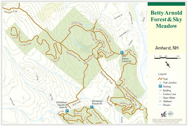
Betty Arnold Forest
Betty Arnold Forest is enjoyed by hikers and mountain bikers for its extensive rugged single track trails. Bicentennial trail runs through the middle, linking this area to Joe English to the north and Daquino Forest to the South. The B-H trails connects to Haseltine (below). For a challenging loop, climb the Lorden Path to the highest point in the area. For an easy walk with kids, try the "I Scream" trail for a 10 minute walk to Tastee Cone. A bench with a view over Sky Meadow is great for quiet contemplation and wildlife viewing. To visit Betty Arnold Forest, use the trailhead parking on Austin Rd.
To view a larger map click on the image or CLICK HERE to download.

Dacquino Forest & Bicentennial Trail
Bicentennial Trail is the oldest in our network. Betty Arnold, matriarch of ACC, established this trail in, you guessed it, 1976. It is good for hiking and mountain biking. It begins across from the DPW and travels north through Daquino Forest, and then on to Betty Arnold and Joe English. At one point it crosses a dirt service road -- find the trail on the other side and stay on it please. This trail is generally easy-moderate, but with a few fairly steep sections. You can access this trail from the trailhead parking at Betty Arnold Forest or there is a small pullout (1-2 cars) on Dodge Rd, north of the DPW.
To view a larger map click on the image or CLICK HERE to download.

Caesar's Brook
Caesar's Brook is among our newer areas. Its on the smaller side, good for an easy-moderate short walk of a mile or less. You'll encounter plenty of natural wonders here including "wolf" trees over 200 years-old and beautiful forest streams. This area is a hidden gem and great for quiet contemplative walks and outings for families with smaller kids.
To view a larger map click on the image or CLICK HERE to download.

Haseltine
Haseltine now has 129 acres of forest and wetland habitat with multiple trails meandering within it. The area has been loved by hikers and mountain bikers for decades and the trail system got a major upgrade after forest management activities in 2016. Trails here are moderate-difficult for hiking and cycling, with lots of roots, rocks, and punchy slopes. A fun spot for kids to climb on massive erratic boulders is at the end of the Rivendell trail, not far from the trailhead. To enter Haseltine, use one of the two trailhead parking areas on Austin Rd.
To view a larger map click on the image or CLICK HERE to download.

Converse Woods
Converse Woods is one of our smaller areas and is good for easy hikes on wide and flat trails. The terrain is also ideal for Nordic skiers. To access this area use the trailhead parking on Pond Parish Rd.
To view a larger map click on the image or CLICK HERE to download.

Joppa Hill
The Joppa Hill conservation area is jointly managed with Bedford and is accessed from the Joppa Hill Farm (on Joppa Hill Rd). Trails here are easy. They traverse forest and grasslands, providing a diversity of natural aesthetics and wildlife viewing opportunities. Sunrise hikes here can be something special.
To view a larger map click on the image or CLICK HERE to download.

Lindabury Orchard
The orchard is an excellent place for a family picnic, birding, and short hikes. The area is composed of a retired apple orchard with hilltop views and wooded areas. Trails form short loops from the orchard into the forest and back. They are moderate difficulty with some steep sections. A cider festival is held here every autumn. To visit the orchard, use the small (2 car) pullout on Christian Hill Rd.
To view a larger map click on the image or CLICK HERE to download.

Patch Hill
Patch Hill trails provide an opportunity to explore historic quarries. These trails are generally easy but have extended gradual slopes to climb and descend. The Patch Hill trail connects into conservation land of the same name in Milford. Access this area from trailhead parking on Lyndeborough Rd.
To view a larger map click on the image or CLICK HERE to download.
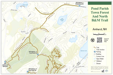
Pond Parish and B&M Trail
Pond Parish is best known for its boardwalk and beaver pond – a great option for a family outing. For those seeking a longer route, the Pond Parish trail connects across Pond Parish Rd to even more trails (See Pond Parish Reservation map below), and the Josiah Parker trail connects across Baboosic Lake Rd to eventually meet the B&M trail. A spur from the Josiah Parker trail will take you to the "corn crib." You can access Pond Parish from trailhead parking lots on Spring Rd and Pond Parish Rd.
To view a larger map click on the image or CLICK HERE.
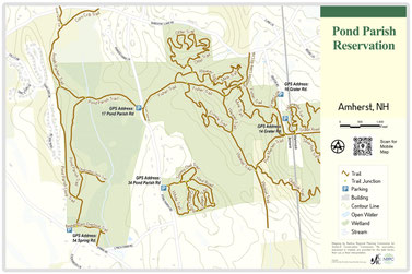
Pond Parish Reservation
Pond Parish Reservation brings together two older areas, Pond Parish and Converse Woods, with our most recent land acquisition, a 200-acre parcel between Pond Parish and Grater Woods (which extends into Merrimack). Together, there's more trail here than most folks can use in a day, spread over more than 1,000 acres! There are multiple trailheads on Spring Rd, Pond Parish Rd, and Grater Rd.
To download the Pond Parish Reservation trail map, CLICK HERE.

Buck Meadow
Buck Meadow is a retired golf course and is being converted into a recreation and nature area in collaboration with the Amherst Recreation Department. It is ideal for easy walks and Nordic skiing on our perimeter trail. Bird watching is excellent. Over time, a natural grassland will be restored and playing fields will be developed near the clubhouse. Access the area from a driveway on Rt. 101A near Siciliano's Landscaping. There is a large parking area at the end of the driveway. You can also find a small trailhead on Stearns Rd.
To view a larger map click on the image or CLICK HERE to download.

Oxbow
Oxbow is a small but interesting area to observe the meander of the Souhegan River over time. Keep an eye out for the various types of wildlife that use the river habitat.
To view a larger map click on the image or CLICK HERE to download.

Atherton
The Atherton trail provides a bit of connectivity to the village. Try it out and see if it might make foot or bicycle travel a feasible way to get to Moulton's or visit a friend in the Village Green.
To view a larger map click on the image or CLICK HERE to download.

Canoe Ports
The Conservation Commission maintains two canoe ports along the Souhegan River:
- The first is on land owned by the Amherst Country Club, along Rt. 122, near the Souhegan River bridge. A narrow dirt driveway runs from the road to a small parking area by the river
- The second ACC canoe port is on Boston Post Road, near the Souhegan River bridge
There is often poison ivy to be found at both canoe port locations. Avoid it!
Be Safe and Protect Nature
When on the trail please be safe and protect our conservation lands:
- Tell someone where you're going if you're headed out alone
- Stay on designated trails
- Be considerate of other trail users
- Carry out your trash (and what you find along the way)
- Clean up after your dog and dispose of properly
- Respect private property
- Wear safety colors during hunting season
- No fires
- No motorized vehicles
Become a Trail Steward
Trail stewards are volunteers that:
- Are trained by the ACC to maintain designated trails
- Operate alone or in teams
- Work whenever and how much they want
Become a steward today.